






The world map that has been used for decades could undergo a significant change, as the United Nations General Assembly has supported the use of maps that more accurately reflect the real size of the continents.
In the vote on the resolution, 164 countries voted in favor, while the United States was the only country to vote against. Six other countries abstained.
At the center of the debate is the well-known Mercator projection, which is widely used in traditional maps, but distorts the size of surfaces, especially near the poles.
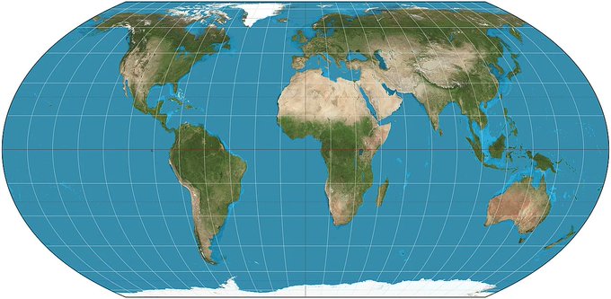
One of the main alternatives is the Flat Earth projection, which aims to more accurately present the size ratio between continents.
The difference is particularly noticeable in Africa. On maps based on the Mercator projection, Greenland may appear roughly comparable to Africa, while in reality Africa is about 14 times larger than Greenland.
With the Flat Earth projection, the dimensions of Africa appear much closer to reality, making it clearer how large some of the continents are compared to how we are used to seeing them on traditional maps.
However, the resolution adopted by the UN is not binding and does not mean that all maps will change immediately. It also does not relate to the use of maps for navigation, but to the way the size and shape of continents are visually represented.
The change aims to bring about a more accurate perception of the world, reducing the distortions created by traditional projections.